Enhancement of Spatial Orientation Capability of Astronauts on the Lunar Surface
This artist???s concept depicts the use of the Lunar Astronaut Spatial Orientation and Information System (LASOIS), during a mission. LASOIS uses a coordinated system of sensors and spatial information visualization techniques to enhance spatial orientation and reduce risks for astronauts during lunar mission operations. Image courtesy of Kevin Gesci, Ohio State University. Click here for larger image.
Principal Investigator:
Rongxing (Ron) Li, Ph.D.
Organization:
Ohio State University
Spatial disorientation occurs when a person has a perception of direction, position and size that does not agree with reality. Sense of such information can have serious consequences for the crew and mission operations. Astronauts will be susceptible to spatial disorientation during lunar mission operations caused by reduced gravity and other factors.
Dr. Rongxing (Ron) Li leads a project to develop the Lunar Astronaut Spatial Orientation and Information System (LASOIS), which will use a coordinated system of sensors and spatial information visualization techniques to enhance spatial orientation and reduce risks for astronauts during lunar mission operations. In addition to developing the system, Dr. Li and his colleagues will develop training that will enhance the spatial orientation capability for astronauts.
NASA Taskbook Entry
Original Aims
The overall goal of this project is to develop a Lunar Astronaut Spatial Orientation and Information System (LASOIS) that will enhance astronauts' spatial orientation capability and reduce sensorimotor risks during future manned lunar mission operations.
Objectives
- To investigate methods for removal and/or alleviation of astronaut disorientation during lunar surface operations by using integrated information technology, and psychological and cognitive research on spatial orientation and navigation.
- To develop the LASOIS system.
- To train astronauts to enhance their spatial orientation capability in a LASOIS-supported simulated lunar environment
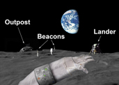
Supported by LASOIS, astronauts on the lunar surface will be capable of overcoming disorientation caused by microgravity and the altered visual environment through spatial information provided by the Earth control center and collected by a coordinated group of sensors from lunar orbit, descending path and ground. The developed spatial orientation strategy, system and training will allow astronauts to have a systematic preparation for complex mission scenarios where spatial operations and efficient interactions and communications are required among the Earth-based control center, lander(s), lunar vehicle(s), outposts and astronauts. This capability is critical for lunar operations that will have an extensive traversing region.
Key Findings - Based on the integrated sensor network established in Year 1, we improved the approaches for processing and integrating spatial data collected by the integrated sensor network, and improved approaches for turning the vast amount of data from the integrated sensor network into necessary, spatial-orientation information usable by lunar astronauts.
- Further development and systematical evaluation of an Extended Kalman Filter (EKF) to integrate measurements from the inertial measurement unit (IMU), step sensor, and stereo cameras. The closure error of a loop traverse of more than one kilometer can be less than 4 percent of the traverse length (500 m) now.
- Improvements of a Kanade-Lucas-Tomasi algorithm for astronaut navigation from video tracking, and explorations about how to utilize various spatial constraints for improving the computational efficiency of this algorithm. An algorithm can run in real-time mode now.
- Development of a Star Tracker technology as a navigation solution in an emergency to improve the flexibility and robustness of the navigation system. Preliminary finding is that the localization accuracy of this approach is 30 km, but the angle accuracy is about 1 degree.
- Development of an approach for matching orbital and ground imagery-based digital elevation models for initial localization of astronauts. The localization accuracy was 12 m on Moses Lake data.
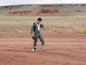
- Design and development of LASOIS prototype. Improved the precision, robustness and mobility of LASOIS through incorporating a tactical inertial measurement unit (IMU), and redesigned of the astronaut boot and on-suit package. Extensive field experiments show that LASOIS prototype V1.0 can support long walks of more than 2 km.
Investigated on different on-suit sensor (IMU, step sensor and stereo cameras) configurations for best navigation capability through extensive experiments. A set of tests of the LASOIS prototype V1.0 were performed at Ohio State University. For example, a trajectory was derived using a tactical IMU and a step sensor. Comparing the derived trajectory to a trajectory determined using GPS, a disclosure of 4 percent was obtained (20 m over 500 m). Two field tests for LASOIS prototype V1.0 were conducted at Plum Brook station and at Black Point Lava Flow in Arizona. We analyzed and summarized these experiments results as research reports for guiding further development of the LASOIS prototype system.
Other research activities include a study on lunar surface beacon systems for astronaut localization. We will also investigate display formats most frequently used in terrestrial environments for navigation aids (plan view, bird's eye view, wingman view, pilot view). Lastly, we will train subjects on how to use the LASOIS prototype V1.0 as well as evaluate displays that the subject will wear when navigating the environment.
Impact of Findings on Project Objectives According to the proposed master schedule, the above mentioned achievements have fulfilled the designated tasks for Year 2. We conducted further tests and improvements of the developed technologies for spatial data processing, integration and spatial information derivation and visualization. These improvements reducing the computational complexity, and improving the precision, reliability and robustness of the system to achieve real-time, high-quality navigation information delivery.
LASOIS prototype V1.0 has been developed and tested. A spatial database containing data collected on all LASOIS test sites is being constructed including high-resolution satellite and ground imagery, videos, measurements from multi-sensory data, and ground truth measured by GPS and field survey. This database will be available to other NSBRI-funded scientists and NASA researchers. All the results and experiences achieved in Year 2 will significantly contribute to the further research and development of LASOIS.
Proposed Research Plan for Coming Year
- Improvement of LASOIS prototype V1.0 by integrating additional sensors (beacons) and considering different astronaut locomotion patterns in a microgravity environment.
- Development of LASOIS prototype V2.0 with real-time navigation capability, integrated on-suit navigation package and robust data integration software for supporting 5 km traverses.
- Utilize LASOIS prototype V2.0 in NASA or NSBRI-led field analog testing campaign. Explore and evaluate visualization approaches for effective delivery of the navigation information to astronauts on a small display.
The Lunar Astronaut Spatial Orientation and Information System (LASOIS) will greatly enhance an astronaut's spatial orientation capabilities, reduce or even eliminate disorientation problems, decrease sensorimotor risks, and ultimately improve astronaut performance and safety while on the lunar surface. It will be the first time that such a spatial orientation and information system was developed and used to improve human performance and human-robotic interaction capabilities in manned missions. Valuable expertise and experience accumulated during the research and development process, especially the analog field test of the LASOIS system, will significantly contribute to the improvement of existing scientific strategies. The outputs of this project will provide NASA with data and knowledge supporting lunar surface science and lunar operations scenarios and will aid the understanding and optimization of human performance capabilities to maximize scientific return in future lunar missions. In addition, with applications developed on the lunar surface, the system could be further extended to support future-manned missions to Mars.
The developed technologies can also be used to support personal navigation tasks on Earth and substantially influence many application domains. Specifically, the spatial recognition results obtained during the process of testing LASOIS can help people understand the relationships between acceleration, gravity and human spatial sensing capabilities. Such relationships can be used in multiple domains, where people work in environments with varying accelerations and require maintaining good spatial orientation in such environments. Examples include first responders working in earthquake sites, people working in deep water environments, and pilots of fighter planes.